Saturday, July 16, 2011

How to Guide for Hiding Caches - Making the Most Out of Free On-line Tools

Hiding a Geocache can be a challenging thing, especially if there are other caches located nearby.  In my experience of hiding Geocaches, so far 2 multi-stages and I am in the process of hiding about 5 more, I found it helpful to use some on line tools for making sure the cache will not be rejected because it is too close to another.

It takes days of planning, marking coordinates, and re-marking coordinates to place  a Geocache, because if you don't it may be impossible for others to find it!  Any GPS unit no matter what brand or how much you spend on it, can vary in accuracy from not only day to day, but hour to hour.  Any experienced Geocacher knows that when you are standing at ground zero of a cache's coordinates that sometimes the signal can be jumping all around.  If you take a set of coordinates one day and return the next day or even the same day at a different time and take the coordinates again, they most likely will not be the same!  So to get an accurate reading, you have to repeat this several times then average the final numbers of the coordinates together to get a reading.  You learn more about averaging coordinates at geocaching.com/forums  If you do all of this work and then submit the coordinates only to have it rejected because they are too close to another cache, it could cause you to have to start all over again.  The rule is that caches have to be .1 mile apart or 528 ft to be precise.  This is to prevent over saturation of Geocaches.


How to Prevent Your Geocache from Being Rejected Because of Proximity Rules


When ever you find a place you want to hide a cache that is near another existing cache, take a set of coordinates at the location where the cache will be.  Then, when you return home, you can use this tool http://www.chemical-ecology.net/java/lat-long.htm to find the distance of that cache to another.  You will first however have to convert the coordinates into Degrees, Minutes, Seconds notation to be able to do this.  This can be done using another handy free on-line tool described below in Converting Latitude and Longitude Coordinates.  Once you get the converted format, simply enter the coordinates for the first point into the Point One columns and the second cache location into the Point Two columns.  Then click the Distance Between button and it will show you in km, miles, and nautical miles the distance between the two points!


Surface Distance Between Two Points of Latitude and Longitude  is a handy free on-line tool for plotting distance between two latitudinal and longitudinal points.  In this example the cache locations are too close together. Click the image to enlarge.


Converting Latitude and Longitude Coordinates


You can convert a set of coordinates easily using the tool http://maps2.nris.mt.gov/topofinder1/LatLong.asp  Enter the set of coordinates provided at geocaching.com for a cache which is usually in Degrees, Decimal Minutes.  There is also a link there to show various conversions.  If you did not use the DDM notation to record the coordinates of a cache you would like to hide, you can use this tool to convert that as well even if you use Decimal notation. 

The State of Montana has a great on-line Latitude/Longitude Converter  Click the image to enlarge.

In the middle of the screen, simply use the appropriate boxes to enter the coordinates then click the calculate button on the right.  Wala!  Your conversions will then appear at the top of the screen. 


Checking to See If You Cache is on Public or Private Property

Another reason you may have a hard time placing a cache is property ownership permissions.  You must get permission from the property owner before placing the cache.  One way of determining if the cache is on private property is plotting the coordinates on a Google map.  How?  You can use a free tool called GSAK which stands for Geocaching Swiss Army Knife.  This tool can be found at http://gsak.net/google/googlemap.php  Navigate to the site and enter the latitude and longitude of your point in Decimal format into the fields.  If you need to convert the latitude and longitude, see Converting Latitude and Longitude Coordinates above.  Once you have entered the coordinates, click the Submit button.  

GSAK is a great on-line tool for plotting a point of latitude and longitude on Google Maps.  Click the image to enlarge.

The coordinates will then display on a Google map.  You can toggle between satellite mode and map mode if you like.  In map mode you can usually see the land parcel numbers for the property blocks.  You can then use this number to determine who the land belongs by looking it up at your county records office.  Sometimes this number is missing, but you can at least see the property boundaries.  If the coordinates are on public lands such as a park, you simply need to contact the government park and recreation department who owns the park.  


GSAK is a great on-line tool for plotting a point of latitude and longitude on Google Maps. Here you can see land parcel numbers in the upper left corner.  Click the image to enlarge.

There is a downloadable verision of GSAK that offers way more features that you can use to track your caches.  It is available on a free trial basis for a certain time period.

Finding the Coordinates of a Location from Google Maps

Another useful tool that is great if you want to find a location to hide a cache first, use the tools above to check to see how far apart the location is from another cache BEFORE you do any leg work.  Then you can use this tool, Latitude and Longitue of a Point by iTouchMap.com.  You can find it at http://itouchmap.com/latlong.html  You can actually select several locations at once as shown below.
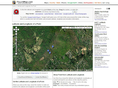

iTouchMap's Latitude and Longitude of a Point is a useful tool for finding coordinates on a Google map. Just click on areas of a map to mark your points of interest. Click the image to enlarge.


If you want to find the coordinates of the one of those points, simply place your cursor over the balloon and click.  This will display the exact coordinates of the selected spot.


iTouchMap's Latitude and Longitude of a Point is a useful tool for finding coordinates on a Google map.  Click on one of the marked balloons to see the coordinates. Click the image to enlarge.
You can also use this tool similar to the GSAK tool mentioned above, however, you can add multiple points on the same map by using the Show Point from a Latitude and Longitude feature shown below.


Monday, July 4, 2011

Thousand Steps near Mount Union, PA

This probably has to be my favorite caching trip to date.  Not only six caches in one hike, but with my son, daughter, two sisters, cousin, his son, and his brother-in-law.  Also, we had to hike to the top of Jack's Mountain using a stairway made of stone that seemed nearly vertical at points to a historic railway site. It was a great time!


Time for a photo opp before the climb
We started off with two caches at the bottom of the mountain, my daughter finding the first, LOST on the Rail (GC2X5XY) rather quickly, picking it right out from underneath my nose, and my younger sister found the second LOST 1.000 Steps (GC2X5X6) after we all overshot it at first.  We had not even hit the first steps yet!   The gang then started the ascent  up the mountain.  

We passed a 71 year old woman attempting the climb!  She only made it to around step 300 then stopped, but dang!  You go girl!


First flight of about a zillion!


The stairway was constructed back in the early 1930s so that the quarry workers could get to the top of the mountain where they quarried a special stone used to make bricks that lined furnaces.  The stone was moved down the mountain using a narrow gauge railroad.  Special locomotives called "dinkeys" would pull the empty gondola cars up the mountain using a series of switchbacks where the train would move back and forth along the mountain pulling forward, then backing up until it reached the top.  


A little history
Example of a dinkey narrow gauge steam engine pulling gondolas

Part of these rail beds make up the trail leading to the top of the mountain.  About every 100 steps or so you get a break and get to walk a short distance on a relatively flat surface that used to be the rail bed then back up the stairs again!


Time to goof off on one of the old rail beds!
My sister ascending to the Earth cache


About 1/3 of the way up the stairs, there is an Earth cache called the 1000 steps earthcache (GC1HWVJ).  This was my very first Earth Cache!  After taking some photos and recording a few answers to the question, we then submitted them in order to log the cache as a find.  It was very cool rock with a fossil on it.


1000 steps earthcache, very cool!
Working on the Earth cache

After we reached the 1000th step, actually about 1030 steps, we hit the top of the mountain (almost).   We paused here where one of the rail beds stretched across the mountain to take in some photo opportunities as the view down the mountain walking out the rail bed was fantastic. 

Family photo opp!
The big family photo opp!


About 3/4 of the way up the mountain, we ran into some nut running down.  He stopped and told us a bit of the history of the quarry and how he was a local and actually works for the company now.  On the three days of the weekends, he does these stairs 3 times a day and can get to the top in 17 minutes!  It took us an hour and a half!  Oy!  He knows people who do this year round, even in the snow!  Uh, I wonder if they've been checked for dementia??

My older sister ascends the stairs with GPS in hand
Towards the top the steps turn into miniature water falls
My daughter stands on the 1000th step very proudly

My son reached the top first and does the Rocky dance
...followed by my daughter
A great view, but we're not quite at the top yet!


Following the rail trail on up the mountain we came to the  4th geocache, LOST on the Steps (GC2X5VE), which my son found after we all did about a 10 minute search.  


My son finds one of the caches
We continued on with our ascent following the dinkey trail until we came to the ruins of the dinkey shed where they serviced the locomotives and cars that broke on the mountain.  The place offered some awesome views of the valley below, however the best view was yet to come.


Approach to the dinkey locomotive shed
Awesome structure.  You can see the service pit filled in with rocks in the middle
View from the dinkey shed
View of the rail switchbacks (where the tree lines are horizontal)
Closeup of the rail switchbacks

Another view of the inside of the dinky shed

We finally reached the location of the original cache on this mountain, the Thousand Steps Cache (GC59AF).  I retrieved an awesome dragon geocoin from this cache which I will pass along on its journey.  The best part of this location was the view at the overlook.  Nothing short of spectacular, you can see the valley below where the Juniata River flows to the east, the main rail line to Pittsburgh, Route 22, and the town of Mapleton Depot.  We paused at this spot for a long time to take in some photo opportunities.


Awesome dragon geocoin I retrieved from Thousand Steps Cache

Spectacular view from atop Jack's Mountain
A bit closer view of the Juniata River and the town of Mapleton Depot below.
My kiddos on top of the world (almost)
I can't believe I forgot my caching hat...


We moved on a bit further out the mountain top to another cache with was my younger sister's second first find of the day.  We also saw a cool lizard on the way to this cache, 1,000 Steps for Ten Thousand Finds (GC2Z3MG), that was one of the biggest I've ever seen of its kind in this area.  I lived in this county for 30 years before moving to Philadelphia and have never seen a lizard that large!


Mr. Lizard entertained us at the top of the mountain
My younger sis finds the last cache on the mountain


After a few more photos at the overlook, we began the descent back down the mountain.  And I'll tell you, wow!  It was twice as hard going down as I had suspected it would be.  By the time we got to the bottom, my knees and ankles were killing me!  However, I would do it again in a heartbeat and we all plan on doing it again next year.  Hopefully, there will be some new caches somewhere to be found!


Cousin and cousin-in-law.  My cousin then proceeded to attempt to heckle some rafters on the Juniata below.  I don't think they heard him!

My two sisters.  This also happened to be the 1 year anniversary that my younger sister introduced us to geocaching!

The descent begins.  This was the last I saw of my son until we reached the bottom!
Passing the dinkey shed on the way down
Passing the 1000 step marker on the way down
Watch your step!  One misstep and you may end up at the bottom of the mountain sooner than expected


The end of our FIRST geocaching adventure on Thousand Steps at Jack's Mountain near Mount Union, PA.  I highly recommend this one!