Sunday, August 29, 2010

Find #87 REVOLUTIONARY WAR RUINS ( GC19FB )

This cache is located at the site of a stand off between British Red Coats and Mary Taylor Frazier during the Revolutionary War.  The British were planning to capture Colonel Persifor Frazier, but he had escaped.  Mary stayed behind to protect the farm and property.


The location of the trail head to this cache is near the old Locksley rail station


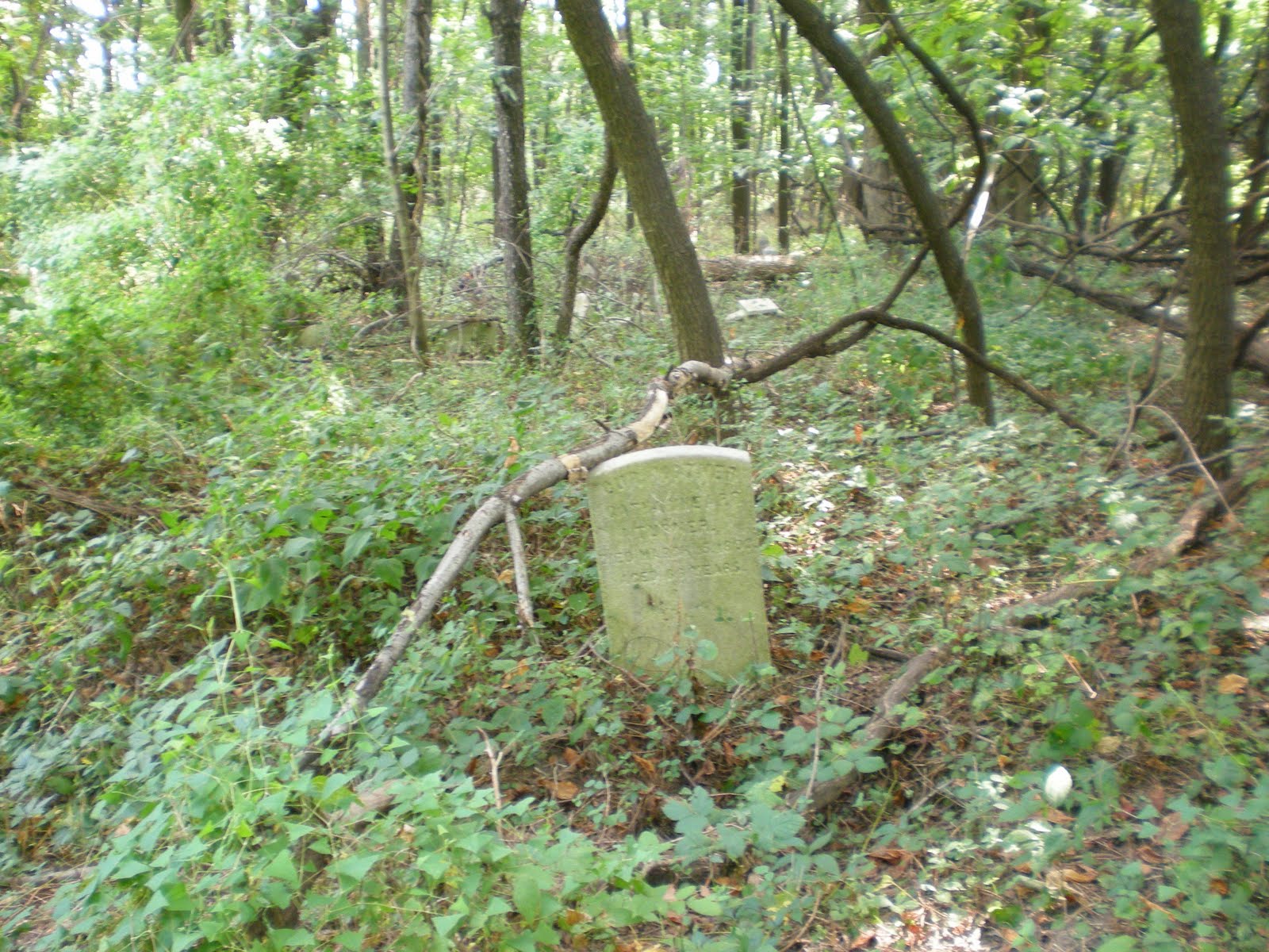
The ruins of the old Frazier Farm


The ruins of the Frazier farm have been preserved in remembrance of the Frazier's fight for freedom.  This site is located in Bonner Park in Thornbury Township, Delaware County, Pennsylvania.

I love this plant.  I would really like to know what it is called.  I dubbed it the "lily pad tree".  It looks like you are underwater looking up through lily pads.

Close up of the fireplace detail in the old house ruins

One of a couple of still standing stone piers which most likely marked the entrance to the farm

If you choose to walk the rail line instead of taking the trails, be careful because the rail lines are active and part of the West Chester Railway. It was once part of the Pennsylvania Railroad.  They give touring rides from West Chester to Glen Mills station.

Watch out if you choose to walk the rails to the cache instead of the trails.  It is an active railway!

Friday, August 27, 2010

Find #85 The Look ( GC1E2AD )

"The look" is located above what seems like America's version of the white cliffs of Dover called White Banks.  This is a great view off of a rock cliff that is almost pure white in places.  Unfortunately, when I found the cache at this site, it was vandalized and there was not much left but a plastic bag.

White Banks of Elk Neck

View out towards the remainder of the Chesapeake Bay and the open ocean.  The small island is located just off shore of the lower point of the Aberdeen Proving Grounds

A view almost straight down from the top of the cliffs.  The top part of the pic is not sky, it is water

View of the Havre de Grace area from the White Banks

Trail map of Elk Neck State Park

Find #80 Elk Neck-Best View Ever!! ( GC920F )

Located at Turkey Point at the very southern tip of Elk Neck State Park, this truly was one of the best views ever!  There is a light house located at the point as well.  This is a great place to visit even if you are not looking for caches!

Now there is something you don't see everyday!

The lighthouse at Turkey Point

Me in front of "The best view ever"

View of light house with the bay to the south

Find #78 Soaking In The Sun ( GC19A81 )

This was my first Maryland cache find.  A great view from the water's edge of Elk Neck State Park of the Chesapeake Bay.  

 Great view of the Chesapeake Bay from just off the parking area

 Havre de Grace and Charlestown areas across the bay


The trails were very well kept and easy to use. There was lots of wildlife to see as well.  Deer, hawks, and yes, snakes also.  There was a great view of the Havre de Grace and Charlestown across the water.

I wasn't the only one using the trails that day.  This deer didn't want to move very quickly.

All creatures great and small...  notice the fly to the left of the butterfly

Great view from the cache site

Tug boat heading inland


Wednesday, August 25, 2010

Find #77 Waterfall Madness ( GC2DBYK )

This was a great little waterfall and pool in the Aston area.  One of my favorite areas I have visited so far.
Trail leading to the waterfall

Waterfall and pool

Nice little fishing area across the pool

The area looked like it may have been used as a canal.  This may be the reason for the dam that forms the waterfall.  Down stream from the falls is what appears like an old raised tow path and a canal next to the stream.

Close up of the falls

Nature's embrace

Possibly an old tow path and maybe a canal

Saturday, August 21, 2010

Find #76 Phobia #7 ( GC124CB )

This cache having to do with the fear of cemeteries, started off rather uneventful.  This cemetery specifically, was Green Lawn Cemetery in Aston, PA.   The GPS showed the cache in a wooded area next to the cemetery.  I started walking through the woods to get to the cache.  I noticed the ground was rather rough and bumpy for being such a flat forested area.  Continuing on looking for the cache, I noticed in the distance in the woods, what looked like an odd rock.  I then stopped realizing that something was note quite right.  The object, it turned out, after looking around and seeing more of them, was a tombstone!  The bumpy areas that I was walking through... were sunken graves!  Ewwwww!  That was such a nasty feeling.  I am so glad I didn't try this as a night cache.  I would have been freaking out for sure.


I turns out this was not the only area of the cemetery that was a tad over grown.  This wooded area just happened to be the worst.  Weeds over 3 feet tall covered many of the graves and markers in the main open cemetery.  What was really sad is that some graves in the wooded area were only from the 1970's.  I would love to know the story about how this cemetery got this way. 


 The shallow depressions are graves


The "regular" cemetery

Friday, August 20, 2010

Find #67 Remember Paoli ! ( GC8C4A )

This was my first "virtual" cache where there was not an actual container to find, but an object that you have to have your picture taken next to.  This location was the site of the September 1777 Battle of Paoli or "Paoli Massacre" during the Revolutionary War.  

 Monument where the soldiers were buried

After his defeat at Battle of the Clouds, General George Washington retreated to Valley Forge to regroup while the British prepared to sieze the city of Philadelphia.  General Washington sent General Anthony Wayne and 2200 soldiers to intercept the General Howe and the British.  Wayne's men encamped at Paoli awaiting reinforcements.  

 Site of the battlefield

The British learned of Washington's plan.  At around midnight of September 20th, the Red Coats sneaked up on General Anthony Wayne's sleeping soldiers and attacked.  Thus ensued the Battle of Paoli.  Wayne's men were massacred and later the British moved on to capture Philadelphia.

Wednesday, August 18, 2010

Find #64 The New World ( GCPV5H )

A bit of interesting history on this one.  Philadelphia is known for Penn's Landing, the famous waterfront entertainment area where various historic and entertainment interests as well as fireworks displays are located.  William Penn, the person whom Pennsylvania is named after since he started it on a land charter in 1682, did not actually first set foot at Penn's Landing, it was the spot near where this cache is located in Chester, Pennsylvania.


This is the sport where Pennsylvania was actually born when William Penn's ship landed here.

Sunday, August 15, 2010

Find #55 Railroad History Part Deux ( GC1541Q )

I have always wanted to visit this site even before I knew anything about geocaching.  It is located on the previous site of the Baldwin Locomotive Works in Eddystone, PA.  A company that was responsible for a large number of the locomotive engines back in the hay day of steam power.

Baldwin Tower

As I pulled into the parking area in front of the still standing Baldwin Tower which was the office building for the company, an  Amtrak Acela passenger train went whizzing by in a blur.  Quite the contrast to the steam engines that were once manufactured here.  Great stuff!

Abandoned tunnel under the existing rail line into Philadelphia

SEPTA passenger train rolling past the Baldwin Tower

Find #53 Psycho Suburban Cache #1: Abandoned Springhouse ( GCZY69 )

The cache owner for this one...  was absolutely nuts!  

 Inside the spring house


I'm not going to give away the location in case there are those who want to find it.  But, you REALLY should not do this one alone.  Let's just say you think "Nah, it could not possibly be in there".  Well, it really IS in there!  

View from the road
View from the top


Be prepared to possibly wade through water, scale walls, craw through tiny spaces, see absolutely nothing unless you have a flashlight...  Take a first aid kit, cell phone, a week's supply of food just in case...seriously! 


Another view from the top

My first logged "Benchmark" (JU0862)

A few times in my life, I've come across strange metal disks either in concrete on sidewalks or on a bridge walkway perhaps and never really knew what they were.  Through the geocaching website, I learned that these are "benchmarks" established by the National Geodetic Survey established by NOAA.  They were primarily used prior to the advent of GPS systems.  They are reference points know to be a high degree of accuracy and many are part of the National Spatial Reference System.


Benchmark JU0862


These reference points can also be posts or stakes in the ground or even the tops of church spires, water towers, radio antennas, etc.

The following is the original logged description of this benchmark  I found:

01/01/1961 by CGS (MONUMENTED) DESCRIBED BY COAST AND GEODETIC SURVEY 1961 (JCC) THE STATION IS LOCATED ABOUT 2.5 MILES NORTHEAST OF CHESTER, 2.5 MILES WEST-NORTHWEST OF ESSINGTON AND IS ON PROPERTY OF THE BALTIMORE AND OHIO RAILROAD. TO REACH THE STATION FROM THE JUNCTION OF U.S. HIGHWAY 13 AND STATE HIGHWAY 352 AT EDGEMONT AVENUE AND 9TH STREET IN CHESTER, GO EAST ON 9TH STREET AND U.S. HIGHWAY 13 FOR 0.42 MILE TO THE INTERSECTION OF 9TH STREET, MORTON AVENUE AND U.S. HIGHWAY 13. TURN LEFT AND GO NORTH ON U.S. HIGHWAY 13 FOR 1.34 MILES TO THE INTERSECTION OF SOUTH FAIRVIEW ROAD AND U.S. HIGHWAY 13. TURN LEFT AND GO NORTHEAST ON SOUTH FAIRVIEW ROAD FOR 0.12 MILE TO THE INTERSECTION OF HAVERFORD ROAD AND SOUTH FAIRVIEW ROAD. TURN RIGHT AND GO EAST ON HAVERFORD ROAD FOR 0.43 MILE TO A T-INTERSECTION. THE INTERSECTION OF CRUM LYNNE ROAD AND HAVERFORD ROAD. TURN LEFT, NORTH, THENCE NORTHEAST AFTER CROSSING THE BRIDGE OVER THE RAILROAD TRACK AND GO 0.06 MILE TO THE INTERSECTION OF GARFIELD AVENUE AND HAVERFORD ROAD AND THE STATION ON THE RIGHT, SOUTHEAST, SIDE OF THE ROAD. TO REACH THE AZIMUTH MARK FROM THE STATION, CONTINUE NORTH-NORTHEAST ON HAVERFORD ROAD FOR 0.16 MILE TO THE INTERSECTION OF FORREST AVENUE, POWERLINE POLE NO. 417 AND THE AZIMUTH MARK IN THE NORTH-NORTHEAST ANGLE OF THE INTERSECTION OF FORREST AVENUE AND HAVERFORD ROAD. THE STATION MARK, A STANDARD DISK STAMPED HAVERFORD 1961, SET IN THE TOP OF AN 8-INCH SQUARE CONCRETE MONUMENT WHICH IS FLUSH WITH THE SURFACE OF THE GROUND. IT IS 210.0 FEET NORTHEAST OF A Y-INTERSECTION AT THE NORTHEAST END OF THE BRIDGE CROSSING OVER THE RAILROAD TRACK, 59.0 FEET SOUTHEAST OF THE INTERSECTION OF GARFIELD AVENUE AND HAVERFORD ROAD, 20.0 FEET NORTHWEST OF THE NORTH EDGE OF A CUT BANK AND 6.0 FEET NORTH OF A STANDARD METAL WITNESS POST AND MARKER. REFERENCE MARK 1, A STANDARD DISK STAMPED HAVERFORD NO. 1 1961, IS SET IN THE TOP OF AN 8-INCH SQUARE CONCRETE MONUMENT WHICH IS FLUSH WITH THE SURFACE OF THE GROUND. IT IS 113.8 FEET NORTH-NORTHWEST OF THE METAL WITNESS POST AND MARKER, 17.0 FEET NORTHWEST OF THE CENTERLINE OF HAVERFORD ROAD, 3.0 FEET SOUTH OF POWERLINE POLE NO 60 AND IS ABOUT THE SAME ELEVATION AS THE STATION. REFERENCE MARK 2, A STANDARD DISK STAMPED HAVERFORD NO 2 1961, IS SET IN THE TOP OF AN 8-INCH SQUARE CONCRETE MONUMENT WHICH IS FLUSH WITH THE SURFACE OF THE GROUND. IT IS 85.4 FEET EAST OF THE METAL WITNESS POST AND MARKER, 37.6 FEET WEST-SOUTHWEST OF POWERLINE POLE NO. 170, 26.6 FEET SOUTH-SOUTHEAST OF THE SOUTHWEST CORNER OF A HOUSE, 14.6 FEET NORTHWEST OF THE CENTERLINE OF HAVERFORD ROAD AND IS ABOUT THE SAME ELEVATION AS THE STATION. THE AZIMUTH MARK, A STANDARD DISK STAMPED HAVERFORD 1961, IS SET IN THE TOP OF AN 8-INCH SQUARE CONCRETE MONUMENT WHICH IS FLUSH WITH THE SURFACE OF THE GROUND. IT IS 26.8 FEET NORTH-NORTHEAST OF THE CENTERLINE OF FORREST AVENUE, 22.3 FEET NORTH OF THE CENTERLINE OF HAVERFORD ROAD, 21.6 FEET SOUTHEAST OF POWERLINE POLE NO. 330, 4.6 FEET NORTH OF POWERLINE POLE NO. 417 AND A STANDARD METAL WITNESS MARKER FASTENED TO THE SOUTH SIDE OF THE POWERLINE POLE AND 1.6 FEET SOUTH OF THE SOUTHWEST CORNER OF A HEDGE ROW AND YARD. HEIGHT OF LIGHT ABOVE STATION MARK 30.2 METERS.


Closeup of the survey disk

#51 Leiper Railway Cache II ( GC2BJB1 )

"Leiper Railway Cache II" was neat in that it was located next to what once was the first surveyed railway in the United States.  It was actually located across the creek from the Thomas Leiper House and Leiper Park.  Thomas Leiper was the founder of the railway.  It was used to haul stone from the Leiper Quarry. The old roadbed is now a gas pipeline, but the old quarry site remains.

 What remains of the old Leiper Quarry

Statley tree along what remains of the Leiper Railway

I had the day before, found "Leiper Railway Cache" across Crum Creek near the Lieper House.  I am currently in the middle of finding "More Railway History (GCZ58Q )" which is a multi stage cache involving the Leiper Railway as well as other railroad history.


The Thomas Leiper House and Leiper Park across the creek from the old railway site

Stage 1 of "More Railroad History"