Saturday, October 15, 2011

Schuylkill RiverTrail - October 2011

On a cool October day my sisters and I met at Valley Forge Park in Pennsylvania.  We did an Earth Cache there and then proceeded on our bicycles to the Schuylkill River Trail.  It was a fun day as we snagged 51 geocaches in one run!  Had we more time, we could have gotten a lot more. Some of the caches were off the path and rather difficult to find so plan accordingly.  It took us 10 1/2 hours and we biked 19 miles.  The caches on this trail are hidden just about every tenth of a mile.  Although be prepared as there are not many places to stop to use a rest room depending on which part of the trail you are on.  You may have to wait until you pass through towns such as Norristown, Conshohocken, or Manayunk. On this run, we traveled from Valley Forge to Conshohocken. Maybe sometime soon I get to do Conshohocken to Philadelphia!

Enjoy the pics!


A map of the geocache smileys we retrieved on the Schuylkill River Trail in one day!
A map of the geocache smileys we retrieved on the Schuylkill River Trail in one day! (click to enlarge)
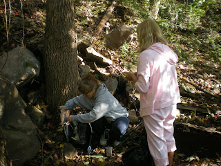
Working the Earth cache at Valley Forge, PA


Getting back on the trail after finding on of the many geocaches on the Schuylkill River Trail
Getting back on the trail after finding on of the many geocaches  on the Schuylkill River Trail


The three of us pause for a Kodak moment


Stopping for a geocache

Making a find a short way off of the Schuylkill River Trail


Beautiful sunset along the Schuylkill River Trail as we head back to Valley Forge

It is scenes like this and the company that made geocaching the Schuylkill River Trail and the 19 mile trip worth while

Saturday, July 16, 2011

How to Guide for Hiding Caches - Making the Most Out of Free On-line Tools

Hiding a Geocache can be a challenging thing, especially if there are other caches located nearby.  In my experience of hiding Geocaches, so far 2 multi-stages and I am in the process of hiding about 5 more, I found it helpful to use some on line tools for making sure the cache will not be rejected because it is too close to another.

It takes days of planning, marking coordinates, and re-marking coordinates to place  a Geocache, because if you don't it may be impossible for others to find it!  Any GPS unit no matter what brand or how much you spend on it, can vary in accuracy from not only day to day, but hour to hour.  Any experienced Geocacher knows that when you are standing at ground zero of a cache's coordinates that sometimes the signal can be jumping all around.  If you take a set of coordinates one day and return the next day or even the same day at a different time and take the coordinates again, they most likely will not be the same!  So to get an accurate reading, you have to repeat this several times then average the final numbers of the coordinates together to get a reading.  You learn more about averaging coordinates at geocaching.com/forums  If you do all of this work and then submit the coordinates only to have it rejected because they are too close to another cache, it could cause you to have to start all over again.  The rule is that caches have to be .1 mile apart or 528 ft to be precise.  This is to prevent over saturation of Geocaches.


How to Prevent Your Geocache from Being Rejected Because of Proximity Rules


When ever you find a place you want to hide a cache that is near another existing cache, take a set of coordinates at the location where the cache will be.  Then, when you return home, you can use this tool http://www.chemical-ecology.net/java/lat-long.htm to find the distance of that cache to another.  You will first however have to convert the coordinates into Degrees, Minutes, Seconds notation to be able to do this.  This can be done using another handy free on-line tool described below in Converting Latitude and Longitude Coordinates.  Once you get the converted format, simply enter the coordinates for the first point into the Point One columns and the second cache location into the Point Two columns.  Then click the Distance Between button and it will show you in km, miles, and nautical miles the distance between the two points!


Surface Distance Between Two Points of Latitude and Longitude  is a handy free on-line tool for plotting distance between two latitudinal and longitudinal points.  In this example the cache locations are too close together. Click the image to enlarge.


Converting Latitude and Longitude Coordinates


You can convert a set of coordinates easily using the tool http://maps2.nris.mt.gov/topofinder1/LatLong.asp  Enter the set of coordinates provided at geocaching.com for a cache which is usually in Degrees, Decimal Minutes.  There is also a link there to show various conversions.  If you did not use the DDM notation to record the coordinates of a cache you would like to hide, you can use this tool to convert that as well even if you use Decimal notation. 

The State of Montana has a great on-line Latitude/Longitude Converter  Click the image to enlarge.

In the middle of the screen, simply use the appropriate boxes to enter the coordinates then click the calculate button on the right.  Wala!  Your conversions will then appear at the top of the screen. 


Checking to See If You Cache is on Public or Private Property

Another reason you may have a hard time placing a cache is property ownership permissions.  You must get permission from the property owner before placing the cache.  One way of determining if the cache is on private property is plotting the coordinates on a Google map.  How?  You can use a free tool called GSAK which stands for Geocaching Swiss Army Knife.  This tool can be found at http://gsak.net/google/googlemap.php  Navigate to the site and enter the latitude and longitude of your point in Decimal format into the fields.  If you need to convert the latitude and longitude, see Converting Latitude and Longitude Coordinates above.  Once you have entered the coordinates, click the Submit button.  

GSAK is a great on-line tool for plotting a point of latitude and longitude on Google Maps.  Click the image to enlarge.

The coordinates will then display on a Google map.  You can toggle between satellite mode and map mode if you like.  In map mode you can usually see the land parcel numbers for the property blocks.  You can then use this number to determine who the land belongs by looking it up at your county records office.  Sometimes this number is missing, but you can at least see the property boundaries.  If the coordinates are on public lands such as a park, you simply need to contact the government park and recreation department who owns the park.  


GSAK is a great on-line tool for plotting a point of latitude and longitude on Google Maps. Here you can see land parcel numbers in the upper left corner.  Click the image to enlarge.

There is a downloadable verision of GSAK that offers way more features that you can use to track your caches.  It is available on a free trial basis for a certain time period.

Finding the Coordinates of a Location from Google Maps

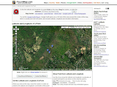
Another useful tool that is great if you want to find a location to hide a cache first, use the tools above to check to see how far apart the location is from another cache BEFORE you do any leg work.  Then you can use this tool, Latitude and Longitue of a Point by iTouchMap.com.  You can find it at http://itouchmap.com/latlong.html  You can actually select several locations at once as shown below.


iTouchMap's Latitude and Longitude of a Point is a useful tool for finding coordinates on a Google map. Just click on areas of a map to mark your points of interest. Click the image to enlarge.


If you want to find the coordinates of the one of those points, simply place your cursor over the balloon and click.  This will display the exact coordinates of the selected spot.


iTouchMap's Latitude and Longitude of a Point is a useful tool for finding coordinates on a Google map.  Click on one of the marked balloons to see the coordinates. Click the image to enlarge.
You can also use this tool similar to the GSAK tool mentioned above, however, you can add multiple points on the same map by using the Show Point from a Latitude and Longitude feature shown below.